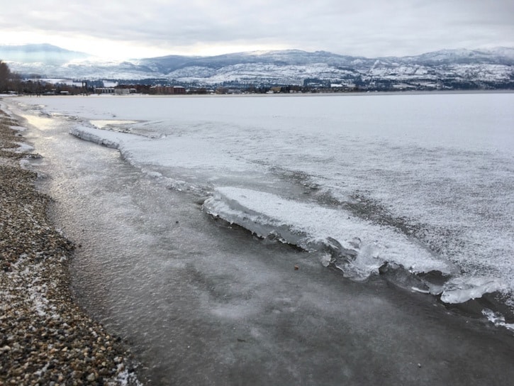
It is a rare sight to see Okanagan Lake's shores frozen over, but it was cold enough this week to make it happen.
This winter's second big cold snap gripped the region earlier this week bringing early morning temperatures on Wednesday to below -20 C.
Those freezing temperatures caused sections of Okanagan Lake's shoreline to actually freeze over, but only a few feet from shore. The last time Okanagan Lake is , but all agree that it was at least 30 years ago.
While this week's sub-zero temperatures up and down the valley were more than 10 degrees below the average at this time of year – they still didn't break any records.
“It's definitely been cold the last few days, there have been some really cold starts to the morning,” said Environment Canada Meteorologist Alyssa Charbonneau.
“We've had a ridge of high pressure that was sitting over B.C., keeping things fairly clear with some small patches of cloud.”
The record low for this week was set on Jan 5, 1907 when the Central Okanagan thermometers dipped to – 28.3. C.
“We have to get colder than it is to break any records,” said Charbonneau. “This time of year those record lows, are really low.”
Wednesday morning was the chilliest in the region with Salmon Arm, Vernon and 91���Ѽ all waking up to temperatures below -20 C.
91���Ѽ came in at -20.5 C, Vernon at - 21 C and Salmon Arm at - 22.7 C. Penticton was not as cold hitting a morning low at -14.2 C.
91���Ѽ's record for Jan. 4 was set in 2004 at - 24 C.
While no new records were set, you're right to feel that this is way colder than normal. The average for the 91���Ѽ area for this time of year is a high of - 0.6 C and -7.6 C for a low.
“This morning was about 10 degrees below average,” said Charbonneau.
For the rest of the week residents can expect temperatures to slowly increase.
“That ridge of high pressure is moving away as a low-pressure system makes its way down from the coast, that is going to spread some cloud and a chance of flurries overnight Thursday and Friday,” said Charbonneau.
Once we hit the weekend, a new weather system will move in bringing warmer temperatures near - 4 C in the afternoon, cloudy conditions and another chance of flurries.
“Cold, but nearly as cold as we've had,” added Charbonneau.
Send your best weather photos, video and news tips to us by heading over to the Contact Us page and sending them in.


